21 Days Yunnan(China)-Northern Vietnam-Laos Cycling Tour from Kunming to Vientiane
Tour Overview
Cycling this route in China and North Vietnam is an introduction to the two mysterious Asian countries. Traditional people, impressive rice terraces and colorful markets. Cycling through quiet valleys...
Code of Tour: TAD0000027705
Length of Travel: 21 Day
Destinations of Tour:
Departure City: Kunming
Price of Tour: Request
Type of Tour: Private
Features of Tour: Minority Cycling Multi-countries
Cycling this route in China and North Vietnam is an introduction to the two mysterious Asian countries. Traditional people, impressive rice terraces and colorful markets. Cycling through quiet valleys and climbing over tough hills. Talking with hands and feet and experiencing something that is completely unique.
With the dry, sunny weather of Yunnan’s winter calling us out of the office, GoKunming took a few days off to cycle south to the Vietnam border. Using Guo Duomi’s post from earlier in the year as a guide, we planned a route through Tonghai (通海), Jianshui (建水) and Yuanyang (元阳) to the border town of Hekou (河口).
The Chinese part of the cycle route leads you through the province of Yunnan, an area with a mild climate all year round and rich flora and fauna. The route starts in Kunming, the capital of the Yunnan province. It is a pleasant and clean city, located at an altitude of 1900 meters.
From here on out you can take a trip to the Stone Forest in Shilin, an impressive natural phenomenon. In Kunming, we have set out a cycling- and walking route for you, so you can easily get acquainted with the most important sights in and around the city.
Day 1 Arrive in Kunming
Arrive in Kunming, transfer to the hotel for checking in.
Day 2Kunming-Guanlingcun to Tonghai
Rapidly increasing traffic on Kunming’s roads, coupled with construction work around Chenggong led us to start our trip the easy way: with mianbaoche transport out of town. For good measure, we got dropped at the top of a hill above Jincheng (晋城) at a place called Guanlingcun (关岭村), on the watershed between the Dianchi and Fuxian lake basins.
We began to ride at the 32km distance marker on the S214 road, at an elevation of around 2100m. We were due to follow the S214 all the way to Yuanyang. A descent of 11km blew away the cobwebs and allowed us to get familiar with the adjusted steering of our laden bikes.
After the descent, we joined the Cuida Road (翠大线) which runs along the western side of the Fuxian (抚仙湖) and Xingyun (星云湖) lakes towards Jiangchuan (江川). As is usual at this time of year, we faced fairly stiff headwind blowing from the south. This would be a feature of every day’s riding.
At around 31.5km completed, we passed through Jiangchuan, pausing to take on water just after the roundabout intersection with the Yuxi (玉溪) highway. The road stays flat for around 5km, before becoming the Jiangtong (江通) highway and heading upwards for a steady 5km climb. This climb took us back up to around 1900m at the highway’s 5km distance marker.
The descent begins with steep downward gradients, but it’s worth a stop for the great views of the town and Qilu Lake (杞麓湖). The slope slowly levels out for the roll into Tonghai on Xiushan Xi Lu (秀山西路). The town sits at around 1800m above sea level.
In all we covered 60km over three hours of riding time. As planned, this was a fairly forgiving first day.
Tonghai’s population is around 200,000, but it’s spread around the lake, leaving a distinctly small-town feel to the place. There’s a strong Hui Muslim presence, and Arabic isn’t too difficult to spot on signs. A large mosque is situated in Nagu Zhen (纳古镇) on the northwest shore of the lake. The downtown lies to the south of S214 as it runs roughly west-east through town.
Day 3 Ups and Downs – Tonghai to Jianshui
We started out early, the morning crisp and cold, with high cirrus clouds in the sky. As the sun rose above the mountains, the town gradually warmed up as we slurped down some rice noodles for breakfast. We had stayed on the S214 road, just near the 93km distance marker, and it was from here we set off toward Jianshui, which we worked out would be at the 170km marker.
The road out of Tonghai is easy to follow, with a gentle 2.5km climb providing a good warm-up. You’ll pass the entrance to the motorway to Jianshui, which is more direct, but not open to bicycles. The descent starts soon after – other than a few bumps, it’s around 15km of descending to the small town of Gaoda (高大, ~1350m). Dress warm for the descent, especially if you’re starting early, as the steep eastern side of the valley keeps stretches of the road in shade.
In Gaoda, watch out for the left turn which keeps you on S214. If you see the 1km marker on S216 (like we did!) you’ve overshot. Back at the left turn, there was a sign we’d seen pointing us to Jianshui on the S216, but closer inspection showed it only applied to large vehicles. Past the turn, the descent continues, but at a lower gradient until you roll into Qujiang (曲江, ~1300m). We stopped for lunch here, just short of noon, with 31.5km on the clock.
Soon after we rolled out of Qujiang, we passed another motorway entrance. The road is undulating, with enough climbs to keep us challenged. At the 136km marker, around 13km out from Qujiang, we were up at around 1500m, and at the 143km marker, we were at around 1650m at the town of Lihao Zhai (李浩寨) and feeling a little worse for wear. Water and a rest helped us refocus.
After Lihao Zhai, there’s a lot more down than up, and the refocusing was complete. The finale comes with a fast drop off into the valley and then a steady descending run into Jianshui. The town’s around 1250m above sea level, which is low enough to start feeling warmer.
At the end of the day, we had 80km on the clock which we’d covered in 4hr 15mins of rolling time.
Jianshui was something of a surprise. The town’s tourism machine seems to be gathering steam. Several sites of interest are clearly marked on roadsigns, and a pedestrian street with restaurants and bars is to be found near the Zhu Family Gardens (朱家花园) off Chaoyang Bei Lu (朝阳北路) where we sat down for teppanyaki and a few well-deserved cold beers.
With the dry, sunny weather of Yunnan’s winter calling us out of the office, GoKunming took a few days off to cycle south to the Vietnam border. Using Guo Duomi’s post from earlier in the year as a guide, we planned a route through Tonghai, Jianshui and Yuanyang to the border town of Hekou.
Day 4 Relish The Descent – Jianshui to Yuanyang
After reading in Guo Duomi’s post that we faced “almost 35km of constant climbing” at the start of the day, we were a little scared as we rolled out of Jianshui at around 10am. The town lies a little off the highway, and we covered around 5km getting back onto the S214 at the 175km distance marker.
Things were not as bad as Guo made out. There’s a 4km climb shortly after you’ve left town, but then it’s pretty much smooth sailing on flat/gradual descent until around the 190km distance marker. Then, there’s a 3km climb, followed by a 3km descent, and then the main event begins: a challenging climb of around 8km which tops out at around 1900m above sea level.
At this point, you’re basically done for the day, as Yuanyang’s new town, which is also known as Nansha (南沙) lies on the Yuan River (元江) at an elevation of around 240m. In other words, mad descending awaits. We shot down smooth roads into the aptly named town of Potou (坡头, slope head) past crowds of waving children, immediately sensing a change in weather and agriculture. A quick lunch in Potou and then we were back into the descent.
The roads are somewhat worn, with patches of unsurfaced road, but nothing a mountain bike and a bit of careful riding couldn’t handle. The descent ends with a few switchbacks which drop you out onto a gravel road running alongside the reservoir formed by the dammed Yuan River. We crossed the bridge and headed into Nansha to find a place to stay and some food.
We’d covered 81km in 4hr 40min of riding.
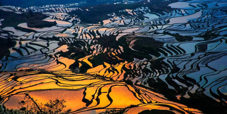
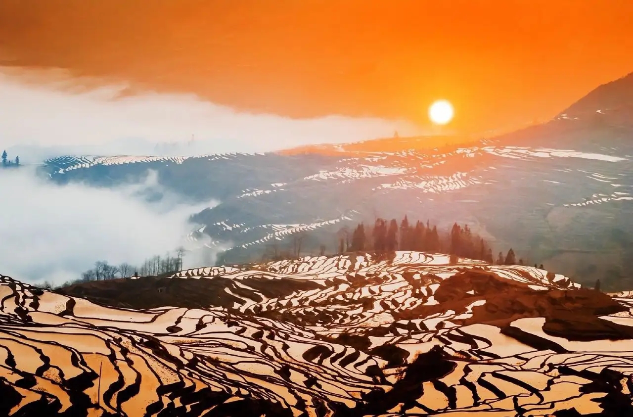
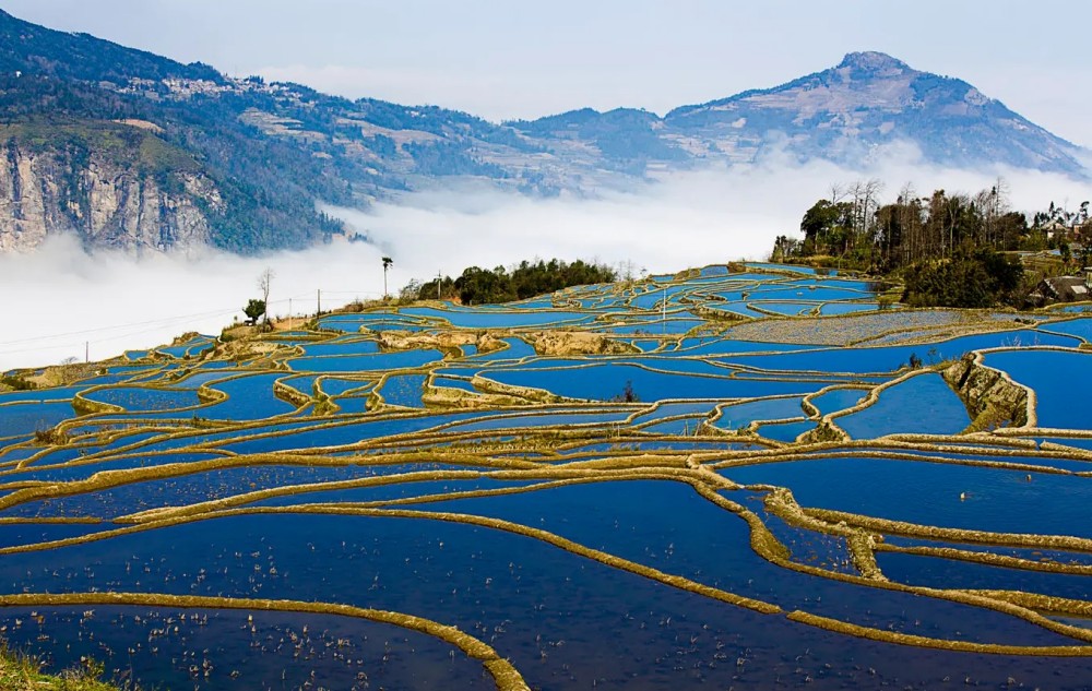
Yuanyang is two towns – Nansha lies on the river, but old Yuanyang, which is famous for its picturesque rice terraces, lies high up on the hillside. Nansha is small and laid out on a simple grid. The low altitude means it’s several degrees warmer than Kunming at this time of year.
Day 5 Yuangyang Rice Terraces cycling tour
This Yunnan sightseeing tour combines a historical discovery in Jianshui and a trip to the rice terraces of Yuanyang. It is designed for those who crave in photography. We strongly recommend you to pick this tour during the Spring as the landscapes are fully blossoming in Yuanyang. More awaits in this tour as you discover the cultural heritages in Jianshui. Learn about the folk customs and cultures of the locals.
This early morning, admire the splendid scenery of the sunrise in Duoyishu. As the reflections and shadows in the colorful water are constantly changing, the visual impact can be overwhelming. Afterward, head to a local market in Shengcun, where you will see the local ethnic people dressed in their traditional clothes and their lifestyle.
After having lunch, drive to the Qingkou Hani Ethnic Village. The mushroom-like houses are undoubtedly the most distinctive in this village. Walk around here and learn about the culture and history of the Hani Minority with a visit to a Hani Showroom in the village. If you fit enough, you may consider walking through the terraces for about 1-3 hours. The last sight today is the Bada Scenic Area. the sunset here is so amazing as the incessantly changing colors will make you feel that you are in a magical kingdom.
Day 6 Yuanyang to Hekou
By now, we’d covered approximately 220km over three days, so you’d think we might make the fourth day easy on ourselves. We didn’t. The plan for the final day was to ride 160km downstream alongside the Yuan River to the border town of Hekou. Elevation was going to be less relevant today, as the road only deviates from the river a couple of times, so major climbs weren’t going to slow us up. Our concerns were road surface quality and headwind. We figured that if we managed an average of 20km/h, we’d still be looking at 8 hours in the saddle.
It’s a ride for time triallists or triathletes: the goal being to maintain a solid effort efficiently for a full day, without cracking. On our side we had an oxygen-rich low-altitude atmosphere and large helpings of obstinacy.
We pulled out of Nansha at around 8:45am, hoping to chomp as many Ks as we could before the headwind got up. We crossed back over the bridge to the north side of the river and turned right for the straight shot towards Hekou. After around 15km, we turned off the Gejiu road and onto the X102, which stays alongside the river. At 42km down, you’ll see a bridge. There’s a bit of a climb here, up to the bustling town of Huangcaoba (黄草坝).
After Huangcaoba, you’ll notice new distance markers, as you’re now on the S212, at the 90km marker. Here we encountered worsening road surface, which brought us well below our target pace. At around 55km down, we found the reason: a dam is being constructed across the Yuan River, and the heavy truck traffic has damaged the surface. Once we’d passed the construction zone, via a 2km inland diversion, the road improved, but we were feeling behind schedule. Time to push the button.
At the town of Manhao (蔓耗镇) the road reverts back to X102 while the S212 crosses a bridge to the south side of the river. The X102 mileposts are reset to zero.
At Xinjie (新街), which is also known as Lianhuatan (莲花滩), there’s a passport check. Expect a few simple questions from the police officers manning the checkpoint. They offered us a refill of our water bottles as we chomped on chocolate.
The road markers change again here, as we’re now on G226 at the 1451km marker. Hekou’s still nearly 70km away, but the police tell us the road is good, and we get to it.
The road is becoming more level, but it’s still undulating gently, with low ‘Tarzan’ hills – if you time your pedaling right, you can use the momentum from a descent to help you up the next ascent. The G226 road has low traffic, mainly motorbikes, because above us is the massive GZ40 4-lane highway bearing the bulk of the region’s traffic.
We keep pushing, but at another roadside passport check near Basa (坝洒), it’s becoming clear we’re not going to make into Hekou in daylight. We end the ride in darkness, grateful to arrive on the well-lit riverside road into the town. We ride all the way through town to the border post, where we find a guesthouse near the bus station. We clock 162km in 8hr 20min of riding, and close the day with cold beers at a riverside stall, while gazing over the river to Vietnam.
Day 7 Hekou Border Crossing-Lao Cai – Sapa – Supan Valley (40km cycling)
In the morning, we will cross the border from Hekou to Lao Cai. Our Vietmese cycling guide and support van will pick you up .
Transfer to Sa Pa up the mountainside and have time to fit bikes before biking into the Sapa Valley. The Queen of Mountains, Sapa sits regally overlooking a beautiful valley, lofty mountains towering over the town on all sides. Sapa is a French hill station that was built in 1922.
Overnight in Sapa (B, L, D)
Day 8: Ta Phin Loop ride full day (30km cycling)
Cycling off-road track to the village of Ta Phin, when the ride will be more challenging in a loop across steep and forested hillsides and minority villages.
Overnight in Sapa (B, L, D)
Day 9:Sapa – Tam Duong (Phong Tho) – Than Uyen (80km cycling)
Cycling shortly uphill as a warm-up to the Tram Ton Pass, before starting a long descent ride to Binh Lu and ride a truly off the beaten track (jeep track) mixed of hard pack gravel and clay to Tam Duong and Than Uyen. Overnight in Than Ueyn. (B,L,D)
Day 10: Than Uyen – Tuan Giao (96km cycling)
Take a brutal ride this day to Lai Chau and Sin Ho and get a reward for truly spectacular views. The ride is on the main road, uphill and tarmac downhill, mixed of gravel and hard pack clay. Overnight in Tuan Giao. (B,L,D)
Day 11: Tuan Giao – Dien Bien Phu (87km cycling)
Take the hardest but most challenging ride this day to Tuan Giao and Dien Bien Phu, on a rough tarmac terrain all the way, but you will be rewarded with the stunningly beautiful scenery and untouched remote villages. Overnight in Dien Bien Phu (B, L, D)
Day 12: Dien Bien Phu – Crossing Border – Muang Khau (70km)
Early morning explore the historical sites of Dien Bien Phu. It used to be the big battlefield between the French and Vietnamese when Vietnam fought again the French to get independence. Then we cycle 70km to Muang Khau by crossing the Laos North-East border at Tay Tran. You have to get a Laos visa in advance to cross the Laos land border. Laos visa on arrival can be obtained only arrival at the airport. This northeast area has the least population in Laos. In the afternoon, we continue cycling to Muang Khua along the Nam Ou river. Overnight in Muang Khau. ( B, L, D)
Day 13: Muang Khua to Oudomxai (75km)
After breakfast, we cycle 75km on the main road to Oudomxai. This is a scenic lightly traveled road to bustling Oudomxai. During the second Indochina War, the provincial capital became the center for Chinese troops supporting Pathet Laos. Today, it is the junction of National Roads 1, 2, and 4 that has made its position a booming alos – China trade center. (B,L,D)
Day 14: Oudomxai to Pak Mong (60km)
After breakfast, we fill in the water and then do a bit of exercise to warm up our muscles. We begin to cycle with a tough climb with hill after hill but the scenery is magnificent. Then take a break to enjoy snacks, fresh fruits, and drinks to get energy before continuing to cycle to Pak Mong. Overnight in Pak Mong. (B,L,D)
Day 15: Pak Mong to Luang Prabang (105km)
Today is our longest bike ride. Early morning, we cycle on the main road passing Ban Thabu. Then we cycle along the Nam Ou river. It is interesting to cycle along the river through villages to enjoy the rural lives. Enjoy a picnic lunch on the river bank and take a power nap before heading to Pak Ou. It has the famous tourist attraction, Pak Ou caves. At the end of the day, we finally arrive at Luang Prabang, the World Heritage town. Dinner and overnight in Luang Prabang. ( B, L)
Day 16: Luang Prabang (Kuang Sii Waterfall) 62km
After a restful day, we hit the bikes for a ride to the stunning Kuang Sii Waterfall. The ride is along a small road alongside the Mekong River passing through small villages, rice fields, and forests. At the waterfall enjoy a swim, picnic lunch, and a visit to the tiger and bear rescue center before riding back to Luang Prabang. (B, L)
Day 17:Luang Prabang to Kiew Ka Cham (78km)
After breakfast. We begin our cycling by heading to Kiew Ka Cham. we are faced with what is, without doubt, the most difficult part of cycling but also one of the most rewarding with two huge uphill climbs. Then we have a 20 minutes power nap before continuing cycling to Kiew Ka Cham. after lunch, We pass through lush forest and many small H’Mong villages that sit dwarfed by the amazing landscape of limestone mountains that surround them. Dinner and overnight in Kiew Ka Cham. Few people stop here overnight so the accommodation is very simple. It is a special experience to stay in such a place. (B,L,D)
Day 18: Kiew Ka Cham to Vang Vieng (94km)
After breakfast, fill in water and be prepared to get on the bike. Today is the hard part of cycling with some up hills and down hills. So, we will start a bit early. It is time to relax a bit as the road is largely downhill along a valley from Kiew Ka Cham, a small village on top of the mountain. in the afternoon You will be high in the mountains for the second half of the day following a ridge line up and down with peaks all around. Overnight in Vang Vieng known as the gate to Northern Laos or backpacker’s paradise a busy town packed with young tourists from all over the world because of its charming landscape and variety of fun activities.(B,L,D)
Day 19:Vang Vieng to Nam Ngum Lake (85km)
After breakfast, we prepare for our hard day biking. We stop every 20km for a drink and snack stop. The overall route is modulated and steep hills in some parts. We will arrive at Nam Ngum lake, the biggest reservoir in Laos. Dinner and overnight on the edge of Nam Ngum lake.(B,L,D)
Day 20:Nam Ngum Lake to Vientiane (80km)
Breakfast at the hotel. Fill in water and be prepared for our biking day. Event Vientiane is a quiet capital city compared to their neighboring countries but the road is still busy. So, we ride to follow a single line and watch for the traffic. We stop in a Hmong market for s short break. Lunch on route. Afternoon, we head to Vientiane, the capital city.Overnight in Vientiane.(B,L,D)
Day 21: Vientiane Departure
after breakfast at the hotel. free and easy.End of the tour.


