14 Days China-Vietnam Cycling Tour from Kunming to Hanoi
Tour Overview
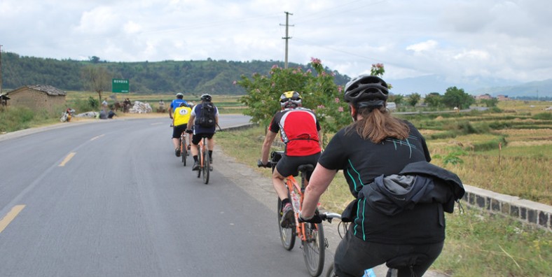
Cycling this route in China and North Vietnam is an introduction to the two mysterious Asian countries. Traditional people, impressive rice terraces and colorful markets. Cycling through quiet valleys...
Code of Tour: TAD0000008035
Length of Travel: 18 Day
Destinations of Tour: Kunming-Hanoi
Departure City:
Price of Tour: Request
Type of Tour: Private
Features of Tour: Cycling
Cycling this route in China and North Vietnam is an introduction to the two mysterious Asian countries. Traditional people, impressive rice terraces and colorful markets. Cycling through quiet valleys and climbing over tough hills. Talking with hands and feet and experiencing something that is completely unique.
With the dry, sunny weather of Yunnan’s winter calling us out of the office, GoKunming took a few days off to cycle south to the Vietnam border. Using Guo Duomi’s post from earlier in the year as a guide, we planned a route through Tonghai (通海), Jianshui (建水) and Yuanyang (元阳) to the border town of Hekou (河口).
The Chinese part of the cycle route leads you through the province of Yunnan, an area with a mild climate all year round and rich flora and fauna. The route starts in Kunming, the capital of the Yunnan province. It is a pleasant and clean city, located at an altitude of 1900 meters.
From here on out you can take a trip to the Stone Forest in Shilin, an impressive natural phenomenon. In Kunming, we have set out a cycling- and walking route for you, so you can easily get acquainted with the most important sights in and around the city.
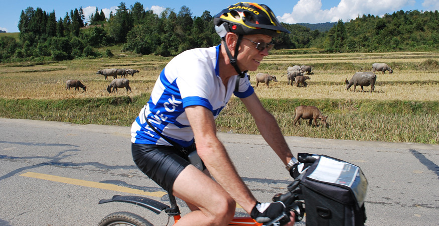
You leave Kunming via the east side of Dianchi Lake and reach the beautiful azure coloured Fuxian Lake that same day. After 2 beautiful stages, you reach Jianshui and you can admire the well-restored, historic downtown. Via a steady climb from 1320 to 1950 meters, followed by a spectacular descent of 40 km, you reach the town of Nansha on the Red River at 235 meters. From here, a visit to the beautiful rice terraces of Yuanyang, the largest and most beautiful in China, should not be missed. These famous rice terraces were laid out thousands of years ago by the Hani people. The terraces are filled with water from November to April and are at their most beautiful during that period. The entire region is on the UNESCO World Heritage List. Cycling along the Red River you reach the border with Vietnam. From Lao Cai, you can make a trip to the mountain village of Sapa where you will encounter various mountain tribes. The route takes you further to the village of Bac Ha, where the women of the Flower H’mong sell their goods at the market. Quiet roads then lead you towards Hanoi. Along the way you see veneer plates drying in the sun and you can enjoy the enthusiasm of many local children. Following the beautiful West Lake, you cycle into Hanoi, a bustling city with lots to explore. From Hanoi you can opt to make an excursion to Halong Bay, a natural wonder on the UNESCO World Heritage List for a good reason. Currently, the roads are being worked on in China. Some roads may be partially broken up during your trip. Alternative transport is always easily arranged as a “plan B”.
Day 1 Arrive in Kunming
Arrive in Kunming, transfer to the hotel for checking in.
Day 2Kunming-Guanlingcun to Tonghai
Rapidly increasing traffic on Kunming’s roads, coupled with construction work around Chenggong led us to start our trip the easy way: with mianbaoche transport out of town. For good measure, we got dropped at the top of a hill above Jincheng (晋城) at a place called Guanlingcun (关岭村), on the watershed between the Dianchi and Fuxian lake basins.
We began to ride at the 32km distance marker on the S214 road, at an elevation of around 2100m. We were due to follow the S214 all the way to Yuanyang. A descent of 11km blew away the cobwebs and allowed us to get familiar with the adjusted steering of our laden bikes.
After the descent, we joined the Cuida Road (翠大线) which runs along the western side of the Fuxian (抚仙湖) and Xingyun (星云湖) lakes towards Jiangchuan (江川). As is usual at this time of year, we faced fairly stiff headwind blowing from the south. This would be a feature of every day’s riding.
At around 31.5km completed, we passed through Jiangchuan, pausing to take on water just after the roundabout intersection with the Yuxi (玉溪) highway. The road stays flat for around 5km, before becoming the Jiangtong (江通) highway and heading upwards for a steady 5km climb. This climb took us back up to around 1900m at the highway’s 5km distance marker.
The descent begins with steep downward gradients, but it’s worth a stop for the great views of the town and Qilu Lake (杞麓湖). The slope slowly levels out for the roll into Tonghai on Xiushan Xi Lu (秀山西路). The town sits at around 1800m above sea level.
In all we covered 60km over three hours of riding time. As planned, this was a fairly forgiving first day.
Tonghai’s population is around 200,000, but it’s spread around the lake, leaving a distinctly small-town feel to the place. There’s a strong Hui Muslim presence, and Arabic isn’t too difficult to spot on signs. A large mosque is situated in Nagu Zhen (纳古镇) on the northwest shore of the lake. The downtown lies to the south of S214 as it runs roughly west-east through town.
Day 3 Ups and Downs – Tonghai to Jianshui
We started out early, the morning crisp and cold, with high cirrus clouds in the sky. As the sun rose above the mountains, the town gradually warmed up as we slurped down some rice noodles for breakfast. We had stayed on the S214 road, just near the 93km distance marker, and it was from here we set off toward Jianshui, which we worked out would be at the 170km marker.
The road out of Tonghai is easy to follow, with a gentle 2.5km climb providing a good warm-up. You’ll pass the entrance to the motorway to Jianshui, which is more direct, but not open to bicycles. The descent starts soon after – other than a few bumps, it’s around 15km of descending to the small town of Gaoda (高大, ~1350m). Dress warm for the descent, especially if you’re starting early, as the steep eastern side of the valley keeps stretches of the road in shade.
In Gaoda, watch out for the left turn which keeps you on S214. If you see the 1km marker on S216 (like we did!) you’ve overshot. Back at the left turn, there was a sign we’d seen pointing us to Jianshui on the S216, but closer inspection showed it only applied to large vehicles. Past the turn, the descent continues, but at a lower gradient until you roll into Qujiang (曲江, ~1300m). We stopped for lunch here, just short of noon, with 31.5km on the clock.
Soon after we rolled out of Qujiang, we passed another motorway entrance. The road is undulating, with enough climbs to keep us challenged. At the 136km marker, around 13km out from Qujiang, we were up at around 1500m, and at the 143km marker, we were at around 1650m at the town of Lihao Zhai (李浩寨) and feeling a little worse for wear. Water and a rest helped us refocus.
After Lihao Zhai, there’s a lot more down than up, and the refocusing was complete. The finale comes with a fast drop off into the valley and then a steady descending run into Jianshui. The town’s around 1250m above sea level, which is low enough to start feeling warmer.
At the end of the day, we had 80km on the clock which we’d covered in 4hr 15mins of rolling time.
Jianshui was something of a surprise. The town’s tourism machine seems to be gathering steam. Several sites of interest are clearly marked on roadsigns, and a pedestrian street with restaurants and bars is to be found near the Zhu Family Gardens (朱家花园) off Chaoyang Bei Lu (朝阳北路) where we sat down for teppanyaki and a few well-deserved cold beers.
With the dry, sunny weather of Yunnan’s winter calling us out of the office, GoKunming took a few days off to cycle south to the Vietnam border. Using Guo Duomi’s post from earlier in the year as a guide, we planned a route through Tonghai, Jianshui and Yuanyang to the border town of Hekou.
Day 4 Relish The Descent – Jianshui to Yuanyang
After reading in Guo Duomi’s post that we faced “almost 35km of constant climbing” at the start of the day, we were a little scared as we rolled out of Jianshui at around 10am. The town lies a little off the highway, and we covered around 5km getting back onto the S214 at the 175km distance marker.
Things were not as bad as Guo made out. There’s a 4km climb shortly after you’ve left town, but then it’s pretty much smooth sailing on flat/gradual descent until around the 190km distance marker. Then, there’s a 3km climb, followed by a 3km descent, and then the main event begins: a challenging climb of around 8km which tops out at around 1900m above sea level.
At this point, you’re basically done for the day, as Yuanyang’s new town, which is also known as Nansha (南沙) lies on the Yuan River (元江) at an elevation of around 240m. In other words, mad descending awaits. We shot down smooth roads into the aptly named town of Potou (坡头, slope head) past crowds of waving children, immediately sensing a change in weather and agriculture. A quick lunch in Potou and then we were back into the descent.
The roads are somewhat worn, with patches of unsurfaced road, but nothing a mountain bike and a bit of careful riding couldn’t handle. The descent ends with a few switchbacks which drop you out onto a gravel road running alongside the reservoir formed by the dammed Yuan River. We crossed the bridge and headed into Nansha to find a place to stay and some food.
We’d covered 81km in 4hr 40min of riding.
Yuanyang is two towns – Nansha lies on the river, but old Yuanyang, which is famous for its picturesque rice terraces, lies high up on the hillside. Nansha is small and laid out on a simple grid. The low altitude means it’s several degrees warmer than Kunming at this time of year.
Day 5 Yuangyang Rice Terraces cycling tour
This Yunnan sightseeing tour combines a historical discovery in Jianshui and a trip to the rice terraces of Yuanyang. It is designed for those who crave in photography. We strongly recommend you to pick this tour during the Spring as the landscapes are fully blossoming in Yuanyang. More awaits in this tour as you discover the cultural heritages in Jianshui. Learn about the folk customs and cultures of the locals.
This early morning, admire the splendid scenery of the sunrise in Duoyishu. As the reflections and shadows in the colorful water are constantly changing, the visual impact can be overwhelming. Afterward, head to a local market in Shengcun, where you will see the local ethnic people dressed in their traditional clothes and their lifestyle.
After having lunch, drive to the Qingkou Hani Ethnic Village. The mushroom-like houses are undoubtedly the most distinctive in this village. Walk around here and learn about the culture and history of the Hani Minority with a visit to a Hani Showroom in the village. If you fit enough, you may consider walking through the terraces for about 1-3 hours. The last sight today is the Bada Scenic Area. the sunset here is so amazing as the incessantly changing colors will make you feel that you are in a magical kingdom.
Day 6 Yuanyang to Hekou
By now, we’d covered approximately 220km over three days, so you’d think we might make the fourth day easy on ourselves. We didn’t. The plan for the final day was to ride 160km downstream alongside the Yuan River to the border town of Hekou. Elevation was going to be less relevant today, as the road only deviates from the river a couple of times, so major climbs weren’t going to slow us up. Our concerns were road surface quality and headwind. We figured that if we managed an average of 20km/h, we’d still be looking at 8 hours in the saddle.
It’s a ride for time triallists or triathletes: the goal being to maintain a solid effort efficiently for a full day, without cracking. On our side we had an oxygen-rich low-altitude atmosphere and large helpings of obstinacy.
We pulled out of Nansha at around 8:45am, hoping to chomp as many Ks as we could before the headwind got up. We crossed back over the bridge to the north side of the river and turned right for the straight shot towards Hekou. After around 15km, we turned off the Gejiu road and onto the X102, which stays alongside the river. At 42km down, you’ll see a bridge. There’s a bit of a climb here, up to the bustling town of Huangcaoba (黄草坝).
After Huangcaoba, you’ll notice new distance markers, as you’re now on the S212, at the 90km marker. Here we encountered worsening road surface, which brought us well below our target pace. At around 55km down, we found the reason: a dam is being constructed across the Yuan River, and the heavy truck traffic has damaged the surface. Once we’d passed the construction zone, via a 2km inland diversion, the road improved, but we were feeling behind schedule. Time to push the button.
At the town of Manhao (蔓耗镇) the road reverts back to X102 while the S212 crosses a bridge to the south side of the river. The X102 mileposts are reset to zero.
At Xinjie (新街), which is also known as Lianhuatan (莲花滩), there’s a passport check. Expect a few simple questions from the police officers manning the checkpoint. They offered us a refill of our water bottles as we chomped on chocolate.
The road markers change again here, as we’re now on G226 at the 1451km marker. Hekou’s still nearly 70km away, but the police tell us the road is good, and we get to it.
The road is becoming more level, but it’s still undulating gently, with low ‘Tarzan’ hills – if you time your pedaling right, you can use the momentum from a descent to help you up the next ascent. The G226 road has low traffic, mainly motorbikes, because above us is the massive GZ40 4-lane highway bearing the bulk of the region’s traffic.
We keep pushing, but at another roadside passport check near Basa (坝洒), it’s becoming clear we’re not going to make into Hekou in daylight. We end the ride in darkness, grateful to arrive on the well-lit riverside road into the town. We ride all the way through town to the border post, where we find a guesthouse near the bus station. We clock 162km in 8hr 20min of riding, and close the day with cold beers at a riverside stall, while gazing over the river to Vietnam.
Day 7 Hekou Border Crossing-Lao Cai-– Xuan Giao – Muong Bo – Sin Chai A
In the morning, we will cross the border from Hekou to Lao Cai. Our Vietmese cycling guide and support van will pick you up .
We commence our cycling day on asphalt road and concrete road lead to Xuan Giao section. We turn off the paved road, cycling along river and hill side, lead to Thanh Phu section. We also cycle on winding route with some bend route and sharps turns. However, we will be rewarded by stunning scenery and extraordinary sightseeing mixed with soaring mountain ranges. Upon arriving of Cau Bo bridge, we spend our time for picnic lunch.
After fulling up energy, we gear up our bike to cycle ascending to Nam Sai on newly paved road lead to Sin Chai A. Enjoy the last 20 km of scenic route to Sin Chai A Village where we stay overnight with Red Dao Hill tribe. Dinner and stay overnight with the family.
Summary:
Activity: Transferring and Warmly up cycling
Accommodation :Eco Homestay
Meals: B/ l/D
Cycling distance: 76 Km
Day 8: Sin Chai A – Nam Cang – Thanh Kim – Ban Ho – Sapa
Wake up early in the morning to participate with local activities or just walk around the village to enjoy pristine nature and peaceful villages. Have breakfast with traditional pancake and banana cake, try herbal tea with the Host . we start our cycling from homestay, passing villages and villages, rice terrace, streams and buffalo road lead to Nam Cang, Nam Sai, Ban Ho, have lunch in Ban Ho with Local Family. After lunch we continue riding up hill on off road and pothole road to Ban Den village for 7 km. Upon arriving in Ban Den. stop for refreshment and fill up energy. We continue to ride on undulating route and steep pass at the end of distance to Sapa Town. You will be fascinated by extraordinary scenery, sublime limestone mountain and peaceful hill tribe villages. Have dinne in Local restaurant, stay overnight in Bamboo hotel
Summary:
Activity: Cycling from village to Hotel
Accommodation: Bamboo Hotel
Meals: B/ l/D
Cycling distance: 54 Km
Day 9: Sa Pa – Ban Xeo – Lao Cai
Breakfast in hotel. We set off our way from hotel.,cycling through the town to national way No 4D. cycling on tarmac road lead to silver waterfall. Turn off in section then we cycle ascendingly to the hill top then down to bridge, turn left on winding route to Muong Hum for refreshment.
After filling up energy, we gear up our bike to challenge scenic road to Ban Khoang Village, we will refresh before descending to Ban Xeo and Muong Hum section. If we are lucky enough,we will meet weekend local market in Muong Hum. We continue to cycle on really amazing route lead to Ban Vuoc for lunch. stop on the way to capture stunning scenery and sublime mountain view, magnificent rice terrace paddy fields. Support vehicle and Picnic lunch will be prepared enroute. After lunch meals. We kick off our pedals to cycle along Red River to Lao Cai City.
Summary:
Activity: Cycling from village to Hotel
Accommodation: Muong Thanh hotel
Meals: B/ l/D
Cycling distance: 74 Km
Day 10: Lao Cai – Muong Khuong – Bac Ha
Have hearty breakfast in Hotel, we depart early to Muong Khuong Sunday Market. Muong khuong is frontier district of Lao Cai province, share border line with Yunnan province, is home of 14 different hill tribe peoples, of which Hmong is majority. Cycling and attending colourful Sunday Muong khuong market is unique and brilliant way to experience and explore the untouched regions, longstanding culture of Hmong people. Additionally, you have chance to capture fascinating landscapes and colourful people on the way to market.
After visiting market, we kick off our pedal to villages, to conquer a long climb a head. We ascend first 7 km to summit and then down hill to Chay river and then challenge 35 km climbing to summit. Today is hard and challenging day for all of us. We ride along frontier road between Vietnam and China lead to Bac ha town, on the way ,we enjoy breathtaking scenic beauty of Chay River and rice terraces on hill sides. Have lunch en route, after lunch meal. We contimue to conquer the last pass before descending to Bac Ha Town.
Summary:
Activity:Transferring and Cycling tours
Accommodation: Ngan Nga Hotel**
Meals: B/ l/D
Cycling distance: 65 Km
Day 11: Bac Ha – Ta Van Chu
After Breakfast, spend an hour walking around the hamlet to meet the locals and enjoy the breathtaking scenery. Gear up to head out along a 2km local trail to pick up the main road, then it’s an 18km climb to Bac Ha. For those who find it tough, your support vehicle will be there to help you up the stunning mountain pass. Getting a short relax for the lunch in a local restaurant in Bac Ha Town before continuing riding in a villager path through Ban Pho village, then heading to Ta Van Chu village for homestay in a Flower Hmong, this is a typical hill tribe in Bac Ha and surrounding area. In this part, you’ll hit a single track trail and dirt road winding through plum gardens and rice fields, and past local homes and inhabitants of the villages. You’ll have a chance to experience the real daily life, dinner and the warm hospitality of your Flower Hmong hosts during this wonderful homestay experience.
Summary:
Activities: Cycling
Accommodations: Ecohomestay in Ta Van Chu
Meals: B/L/D
Cycling distance: 42 Km
Day 12: Quan Than San – Can Cau – – Lung Phinh – Ban Lien
Breakfast with the traditional serve from your host, farewell them by taking photos before leaving. Cycling 5km through the forest and heading to Quan Than San village on the rock and dirty road in some parts. Gear to head Simacai for 12km for riding down to Can Cau market (only on Saturday). This is the great time for discover the unique and original market in the North-West of Vietnam, enjoy some typical local food for lunch. Keeping your impressive trip by taking many photos which will be shown for your friends and family with their surprised eyes. After visiting Can Cau market, our route will be cycling back to Bac Ha with the distance of 20km. have lunch in Bac Ha town.
Following to lunch meals, we continue our trip to Ban Lien Village where we stay over night.
Summary:
Activities:Cycling and visiting
Accommodation: Ban Lien Village
Meals:B/L/D
Cycling distance: 41 Km
Day 13: Ban Lien – Nam Khanh – Tan Duong – Hanoi
Following breakfast, visit the biggest and colorfull and impressive market of Vietnam mountainous area. After spending 2- hours for market, our support vehicle take you back to homestay for check out. We gear up our bike from farm stay to ride on hillside and corn farm to Nam Det village then turn on single track to asphalt road lead to Tan Duong Section. We have picnic lunch in tan Duong. After lunch, loading up our bike and luggage on vehicle/ taking transfer 4 hour on new highway back to Hanoi.
Summary:
Activities: Cycling and Transferring by bus
Accommodations: By Yourself
Meals:B/L/D
Cycling distance: 45 Km
Note: Hotels are subject to change due to availability. In that case we will choose equivalent accommodation
Meals: if you have any specific food requirements ( vegetarian, vegan, food allergies) please inform us in advance so that we can provide notice to our restaurant, tour guide, our partners so that they can server you better. If you are a food lover, Snail Adventure tours can be your culinary guide and provide you opportunity to savor tempting local food and world famous – dishes.
Day 14 Departure from Hanoi
The cycling tour will be finished today. You can continue your sightseeing tour in Vietnam.
Service ends.


